
 Powder Alert – sent January 17
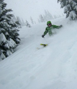
I’ve heard a lot of fantastic reports about the powder of yesterday, Friday the 16th. Hope you had a good one; I had been targeting that day since last week and it worked out pretty well.
The next weather system is now in progress and has multiple personalities – but in the end is our friend.
Expect a snow level (SL) today of 3000ft and increasing snow (1-4″). The bummer with this storm is it a has a warm sub-ropical connection and the snow level will rise to 7000ft later tonight (Saturday) with moderate to heavy rain on the snowpack for about 6-8 hours. Remember, that process doesn’t really melt that much snow, but it does consolidate the snowpack and increase snowpack density.
By early Sunday morning (1am to 5am) the storm will “friend” us with lower snowlevels and cooler air. I expect 3-8″ new snow by noon-ish Sunday – but it depends exactly how the timing unfolds. A snow level of 3000ft by near lunchtime will be seen. Wind could be an issue with gusts 20-40mph. I favor Monday (MLK holiday for some) with the wind decreasing, new snow in place, low snow levels near 2500ft, some sun breaks possible and new snow ( 3-9″). Groomers should be stellar.
Next week looks dry, with a ridge of high pressure moving in. Then a weak system brushes us on Thursday with light snow possible. The good news is the snowpack and coverage has improved from the new snow lately. The not so good news is…the trend toward the end of January is for below normal precipitation – not zero snow, just trending low. Oh no, say it ain’t so, Mr. Poobah!
Go Seahawks!
As always, with fondest regards and a salute to your good health,
Your Excellency
The Grand Poobah of Powder
