 Magnificent Monday and Terrific Thursday Ahead!
This pair of Cascade powder days, brought to you by SkiWashington.com, K2 skis, Gore-Tex and home grown: OR gear.
Snow levels are dropping this evening and now it’s mainly snowing in the Cascades. Cool northwest flow will really help us this week, favoring low snow levels.
With the cold air streaming in, the snow level will bottom out near 2000ft on Monday and that is mighty fine. Expect 8-13″ new – now you are speaking my language.
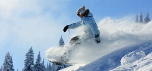
Monday: POWDER ALERT. Baker and Stevens may have more snow, because cold air moved north to south, so they got an earlier start on the lower snow levels. Monday will see snow tapering off for all, so some bluebird may be seen. Groomers will be primo and expect lots of untracked powder.
I also like Tuesday with partial clearing, with continuing cool temperature to preserve snow conditions, all with quality leftovers – also some new snow (2-4″).
By Wednesday a respectable new storm will produce (4-9″) with a SL of 3000ft during the day.
The snow continues into Thursday (5-9″new) and snow level lowering to 2000ft and that is good. The cooler air will produce improving quality with fantastic refill dumpage. As a result, bearing in mind the power bestowed upon me by unknown authorities, I herby issue a Powder Alert for Thursday. Two alerts in one week, I must get a free sandwich, frequent flyer miles or something.
Expect little or no new snow Friday with continuing quality groomers. Weekend: partly sunny with spring skiing
Your Grand Poobah of Powder
Larry Schick – meteorologist